Geol 1070
Earth and its Physical
Environment
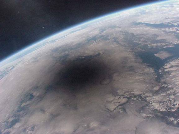
Shadow of the Moon caused by a full solar eclipse
(Photo from NASA
astronaut photography web site)
LINK TO CLASS SYLLABUS
CLASS
MATERIALS: HANDOUTS, REVIEW SHEETS, ETC…
UNIT
1: LOCATING PLACES ON THE PLANET, Co-ordinates, Maps and Resources
Jan. 11: Conversions: Handling & Converting numbers
Interesting Links:
Practice Sheet for Conversions
Jan.
18: Global
co-ordinate systems, Longitude and latitude, Maps and Projections
Interesting
Links:
U.S.G.S. Map Projections Poster Web version of the map
projections poster from class
Find your House! Zoom
in on aerial photographs anywhere in the U. S.
Jan. 20: Old Maps, Latitude and the “Longitude
Problem”; Township and Range System
Interesting
Links:
John
Harrison’s Chronometer #1 That’s
quite a pocket watch!
Harrison’s
Chronometers #2 and #3 A
little bit less ugly…
Number
4 is a charm The
4th Harrison Chronometer
Jan. 23: Topographic Maps, Contouring, GPS
Basics of
Topographic Maps
How GPS works A
useful site explaining how GPS works
Jan.
25: Topographic Maps: Advanced
Look at U.S. topography State-by-state
topography and shaded relief maps
Look at World
topography Clickable
shaded relief/topographic map of the World
Jan.
27: Exam #1: Maps and locations
Example
of previous year’s exam
UNIT 2: GEOLOGY
Subunit A: Plate Tectonics
Jan. 30: Internal Structure of the Earth, Earthquakes
and Seismic Waves, the Earth’s topography
Diagrams of the Earth’s
Interior
More
Diagrams of the Earth’s Interior
Feb.
1: Seismograms, locating an
Earthquake Epicenter
Real-Time
Earthquakes: California
More on the
2004 Sumatra Earthquake (including cool tsunami model)
Feb.
3: Plate Tectonics I: How do we
identify the Tectonic Plates:
Global Distribution of Earthquakes, Volcanoes and topography
“This Dynamic
Earth” U.S. Geological Survey Tectonics Page
Computer
Programs showing seismic waves, volcanoes, etc…
(THIS
IS VERY COOL!)
Plate
Tectonics: Types of Boundaries
Feb. 6: Plate Tectonics II: Ridges, Trenches and
Transforms. Hot Spots Lab.
Feb. 8: Plate Tectonics III: Evidence for Plate
Tectonics
Plate motions from GPS
– Some maps
Continental Drift and Plate
Reconstructions
Feb. 10: Exam #2 (Plate Tectonics)
Subunit B: Rocks & Minerals
Feb.
13: Organization of Matter; Atoms to
Elements, What is a Mineral? Mineral Density
The
Structure of Matter Powerpoint
about Atoms & the Structure of Matter
Mineral Structure
Diagrams Informative
page showing some packing structures
Feb. 15: Minerals
and Mineral ID Lab
Mineral ID
guide An
online primer on rock and mineral ID
Mineral
Pictures Gallery of mineral photos listed by name
Feb. 17: The
Rock Cycle, Igneous Rocks
Mineral ID
guide An
online primer on rock and mineral ID
Mineral
Pictures Gallery
of mineral photos listed by name
Igneous Rocks Guide
to igneous rocks
Feb. 20: Weathering,
Erosion, Sediments and Sedimentary Rocks and Environments
The
difference between Weathering & Erosion
Sedimentary Rocks
Guide to
Sedimentary Rocks
Feb. 22: Conversion
of Sediments to Sedimentary Rocks. Metamorphic Rocks
Metamorphic
Rocks Guide
to Metamorphic Rocks
Feb. 24: Exam #3
Example
of previous year’s exam
Subunit C: Our Physical Environment:
Geologic Structures
Feb.
27: Geologic Timescale, Formations, Horizontality/Superposition; Folds &
Faults
March 1: Geologic
Structures, Cross-Cutting Relationships, Relative Dating
March 3: Radiometric Dating
U.S. Geological Survey
page on radiometric dating
e; folds faults
March 6: Geologic Maps:
Map of Laramie Range & Geohydrology
March 8: History of Life
March 10: Exam #4
(Geology)
THIS
IS A COMPREHENSIVE EXAM!!!
MARCH 14-18 SPRING
BREAK
UNIT 3: ASTRONOMY
March 20: Astronomy Intro:
Units and Orders of Magnitude, Distances, Scales, Powers of Ten
Powers of Ten
“Official” Website
Practice Sheet for Conversions
March 22: The Solar System:
A Visual and Virtual Tour, Gravity
Virtual
Fly-Through of Solar System
A Virtual Tour of the Solar System
March 24: Distances to
Planets, Log Scales
Scale Model of the Solar
System “Calculator”
Highway-side Scale Model of
the Solar System in Maine
Links to Examples of Model and Map
Scales
March 27:
Sun-Mercury-Venus-Earth-Moon Scale Model
March 29:
Distances to Objects: Parallax, Light, Luminosity, Red-Shift and Doppler
Effect
March 31: Seasons and Phases
of the Moon
Seasons: NASA website
explaining Earth seasons
April 1: Comets, Asteroids,
Meteors & Meteorites: Crater Impact Lab, Kinetic Energy
3-D graphics of
simulated impacts (from Sandia Labs)
Images and Diagrams of
Craters on Earth
Meteor
Crater (Arizona, USA) Web Site
April 5: Planetarium Visit
April 7: Astronomy
Unit Exam
March
25:
UNIT 4: METEOROLOGY:
Weather & Atmosphere
April
10: What’s in the Air? Heat & Water,
Convection, Phase Changes
The
DataStreme Atmosphere Project
April 12: Relative
Humidity; Dewpoint
April 14: No Class-Easter Break
April 17: Air Pressure-Temperature-Altitude Relations.
Air Masses, Clouds
April 19: Coriolis Effect, Global Air Circulation
April 21: Air Masses. Low
& High Pressure Centres Weather Maps
and Fronts
Howstuffworks
"How Tornadoes Work"
April 24: Weather Maps II
The National Oceanic & Atmospheric
Administration Web Page
April 26: Exponential Growth: population growth &
the future of the Earth
April 28: Meteorology Unit Exam
Review
Sheet for Meteorology Exam