Homework #9 2012, Earth Surface Processes,
Humphrey
We have been talking
about the variability of river discharge.
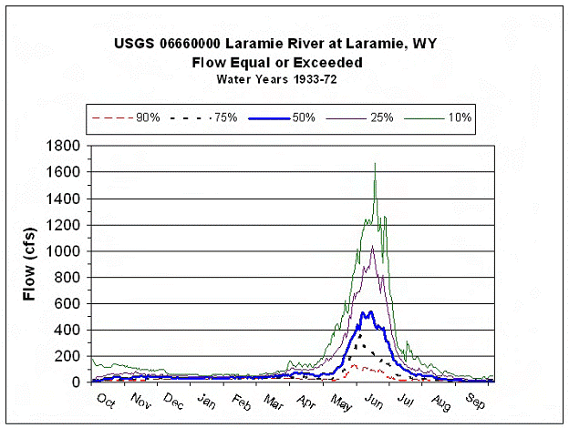
There are many ways of looking at how river discharge varies. A useful type of plot is shown below, which
nicely shows that the Laramie river typically has only
one flood (snow melt dominated) in early summer.
For this exercise, we
are going to look at something that is of major interest to many, the question
of the likelihood of large floods. Here
is some recent data from the Laramie river at Laramie
(this is the only recent data of which I am aware):
Flow measurements as
reported on UPRR quarterly Discharge Monitoring Reports (DMR) for WDEQ Permit
WY0032590,
Laramie
Tie Plant.
Year
Oct
Nov Dec
Jan Feb
March Apr May June July
Aug Sept
Streamflow (cfs)
1987 8.1 77
49 54 65 62
157 46 22 7.8 4.5
1988 28 40
26 7.9 7.0 68 201
508 680
48 8.9
5.5
1989 17 44
34 7.1 2.0 61 nr
16 45 13 11 13
1990 36 75 60 27
30 189 36 30 351
50 20
10
1991 7.9 41
76 11 24 104 20
169 612 19 21 11
1992 231
1993 49 102
147 196
264 309
39 407
1016 115 11 36
1994 14 38
67 177 209 93 53
288 77 7.6 7.0 4.7
1995 45 55
53 86 65 68 6.8
111 1281 281 14 15
1996 51
62 88 77 68 79 107
552 1136
420 20
21
1997 115 128
115 55
62 82 101 503 1277
149 110
87
1998 34
55 63 70 75 87 100
305 425
139 66 29
1999 20 18
67 56 60 75 68 496 1126 267 20
17
2000 18 40
13 84 72 45 54
297 101 18 6 13
2001 56
20 54 77 90 75 21
177 66 11 18 26
2002 11 16
21 160 207 174 32
68 56
2003 18
49 68 28 22 22 20
230 556 14
2004 131 122
113
68 83 72
2005 47 49
81 94 98 90 53
306 1115 95 80 16
2006 188 201
200 126
109 107
159 386
105 187
109 115
2007 143 104
68 200
186 281
146 549
378 78
109 34
2008
68
68 68 98 469 1715
316 180
169
The
above table shows several problems with flood analysis. Real data sets have missing and questionable
data. The above table lists measurements
taken once a month, obviously it probably misses the actual flood peaks. There are more subtle problems with stream
data: even if you find more continuous data (e.g. USGS typically reports daily
discharge), the actual discharge is not measured, but estimated from river
depth. Any bed or bank erosion or
deposition will create errors in this depth based estimate,
this is especially a problem at high flows when erosion/deposition is common. The biggest problem with the Laramie river data, is that over time, various water projects have
diverted water from the river. As a
result, the flood data is not ‘stationary’, in other words the flood data does
not represent a sample from the same river over time. The river has been changing, so that we can’t
trust the old data to predict the future.
To
continue our analysis we will use a better data set as shown below.
Grey
River, at Dobson New Zealand
1968
to 2004
|
year |
Max flow (m3/s) |
|
|
|
1997 |
5950.8 |
|
|
|
1988 |
5840.4 |
|
|
|
1998 |
5670.0 |
|
|
|
1970 |
4899.1 |
|
|
|
1994 |
4844.5 |
|
|
|
1977 |
4841.4 |
|
|
|
1984 |
4814.3 |
|
|
|
1983 |
4228.2 |
|
|
|
1969 |
4203.4 |
|
|
|
1972 |
4125.6 |
|
|
|
1975 |
4117.8 |
|
|
|
1980 |
4039.4 |
|
|
|
1973 |
4012.5 |
|
|
|
1979 |
4000.9 |
|
|
|
1982 |
3975.2 |
|
|
|
1996 |
3866.7 |
|
|
|
2000 |
3809.5 |
|
|
|
1974 |
3771.7 |
|
|
|
1968 |
3678.3 |
|
|
|
2002 |
3517.9 |
|
|
|
1976 |
3463.4 |
|
|
|
1981 |
3448.9 |
|
|
|
1993 |
3422.3 |
|
|
|
2001 |
3342.7 |
|
|
|
1978 |
3302.9 |
|
|
|
2004 |
3224.6 |
|
|
|
2003 |
3221.9 |
|
|
|
1989 |
3217.1 |
|
|
|
1995 |
3185.8 |
|
|
|
1992 |
3177.6 |
|
|
|
1991 |
3091.4 |
|
|
|
1999 |
3070.0 |
|
|
|
1990 |
2806.8 |
|
|
|
1971 |
2420.5 |
|
|
|
1987 |
2385.4 |
|
|
|
1986 |
2364.9 |
|
|
|
1985 |
1794.8 |
|
|
|
|
Mean 3761.0 |
|
|
|
|
|
|
|
Question 1
a. Calculate the recurrence intervals for floods on the Grey River. There are a variety of methods to calculate recurrence interval, but probably the simplest is as follows: order your data from largest to smallest (this I have done for you). Now apply the following formula to each datum:
Tr = (N+1)/n, where N is the total number of observations, n is the ranking in the above list from top to bottom (eq the second from the top is n=2) and Tr is the recurrence interval in years.
b. Plot the recurrence intervals on a semi log plot. Use log time on the x-axis and discharge on the y-axis. We will use a log axis, however there is considerable discussion in the literature about the expected shape of a recurrence interval curve, or more precisely, how floods should be distributed in time. (If you would like to investigate this more, look up Gumbel Distribution on the web.) We use a log plot since it is straightforward to plot, not because it is correct.
c. Use your plot to estimate the 100year flood on the Grey river. Comment on the accuracy of your prediction.
d. The channel forming discharge for a meandering river is typically about the 2year flood. What is the 2 year flood on the Grey River.
Question 2
This is a follow-up to last week’s homework, question 2, which most of you missed because you assumed that the depth of a river didn’t change, when I asked about the slope changing. So a slightly different question:
a.
How does the basal shear stress in a river
change if the river enters a section where the slope is doubled? Assume width and discharge and sediment in
transport stay the same. You can
approach the problem with the Manning’s eqn and
discharge continuity.
b.
Since the size of the material on the bed will
probably change, and Manning’s n will increase slightly: will the increase in ‘n’
increase or decrease the basal shear stress.
Question 3
We introduced Hydraulic Geometry in class. Remember, these relationships have no physics in them, they are only compilations of real world data on how real river behave. I presented some equations for the downstream changes in the major stream variables. By mistake, I actually gave you the ‘at a station’ equations, in other words the equations that describe how a river location changes as discharge changes. So here we will investigate a little.
width = a Qwb, depth = c Qwf, velocity = k Qwm
where b = .26, f = .4 and m = .34, and Qw is the water discharge. The values of a, c, and k are dependent on each river and highly variable.
a. Explain why b+f+m should equal 1 ! (big hint: width * depth * velocity should equal Qw at any point of the river). While you are thinking about this, explain also why a*c*k should also be 1?
b. (needs careful thinking) Let us investigate whether the hydraulic relations match what we know about the behavior of rivers from our work with the more theoretically based equations such as Manning’s equation. We know from our discussion in class that the slope of a river changes very slowly. Assume it doesn’t change over a flood. Also assume Manning’s ‘n’ is constant. Now compare the results of the hydraulic geometry equations to a doubling of discharge, to the results you get from Manning’s equation. (Hints: if it makes you more comfortable, you can assume values of a=2, c=.5, k=1, although they are not needed. Try substituting the hydraulic geometry equations into Manning’s equation. Don’t forget to include the width in Manning’s equation for total discharge. Use depth, not hydraulic radius in Manning’s)
c. (puzzle) If you use the more correct hydraulic radius instead of depth in question b above, does it improve the match between hydraulic geometry and Manning’s formula?
c.