Homework #11 2020, Earth Surface Processes, Humphrey
There
are a lot of calculations in this homework, take your time and think a little.
We have talked about
the variability of river discharge.
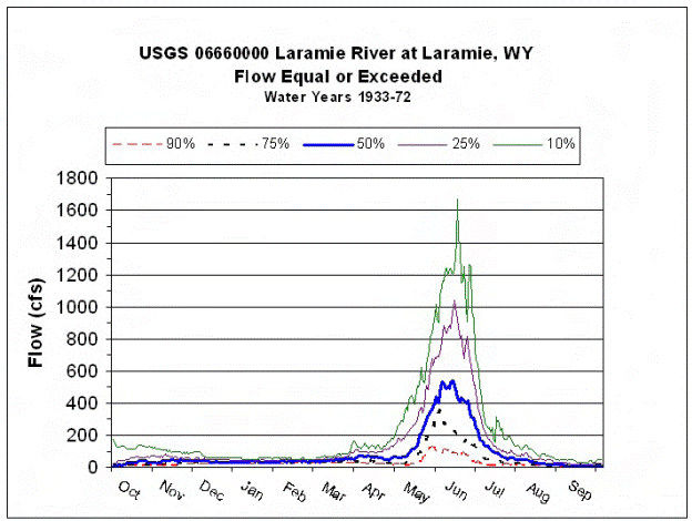
There are many ways of looking at how river discharge varies. A useful type of plot is shown below, which
nicely shows that the Laramie river typically has only one flood (snow melt
dominated) in early summer.
For this exercise, we
are going to look at something that is of major interest to many, the question
of the likelihood of large floods.
First, we will at some
better quality data than the Laramie River.
Question 1, recurrence intervals (or what the media loves to report,
the eponymous ‘100 year floods’)
Grey
River, at Dobson New Zealand
1968
to 2004
|
year |
Max flow (m3/s) |
|
|
|
1997 |
5950.8 |
|
|
|
1988 |
5840.4 |
|
|
|
1998 |
5670.0 |
|
|
|
1970 |
4899.1 |
|
|
|
1994 |
4844.5 |
|
|
|
1977 |
4841.4 |
|
|
|
1984 |
4814.3 |
|
|
|
1983 |
4228.2 |
|
|
|
1969 |
4203.4 |
|
|
|
1972 |
4125.6 |
|
|
|
1975 |
4117.8 |
|
|
|
1980 |
4039.4 |
|
|
|
1973 |
4012.5 |
|
|
|
1979 |
4000.9 |
|
|
|
1982 |
3975.2 |
|
|
|
1996 |
3866.7 |
|
|
|
2000 |
3809.5 |
|
|
|
1974 |
3771.7 |
|
|
|
1968 |
3678.3 |
|
|
|
2002 |
3517.9 |
|
|
|
1976 |
3463.4 |
|
|
|
1981 |
3448.9 |
|
|
|
1993 |
3422.3 |
|
|
|
2001 |
3342.7 |
|
|
|
1978 |
3302.9 |
|
|
|
2004 |
3224.6 |
|
|
|
2003 |
3221.9 |
|
|
|
1989 |
3217.1 |
|
|
|
1995 |
3185.8 |
|
|
|
1992 |
3177.6 |
|
|
|
1991 |
3091.4 |
|
|
|
1999 |
3070.0 |
|
|
|
1990 |
2806.8 |
|
|
|
1971 |
2420.5 |
|
|
|
1987 |
2385.4 |
|
|
|
1986 |
2364.9 |
|
|
|
1985 |
1794.8 |
|
|
|
|
Mean 3761.0 |
|
|
|
|
|
|
|
To start our thinking about river floods, we will look at some (good quality) data from the Grey river in New Zealand.
a. Calculate the recurrence intervals for floods on the Grey River. Recurrence intervals are what are usually somewhat misleadingly quoted in the popular media as the 100 year flood or whatever the news person wants to emphasize. There are a variety of methods to calculate recurrence interval, but probably the simplest is as follows: order your data from largest to smallest (this I have done for you). Now apply the following formula to each datum:
Tr = (N+1)/n, where N is the total number of observations, n is the ranking in the above list from top to bottom (eq the second from the top is n=2) and Tr is the recurrence interval in years.
b. Plot the recurrence intervals on a semi log plot. Use log time on the x-axis and discharge on a linear y-axis. We will use a log axis, however there is considerable discussion in the literature about the expected shape of a recurrence interval curve, or more precisely, how floods should be distributed in time. (If you would like to investigate this more, look up Gumbel Distribution on the web.) We use a semi-log plot since it is straightforward to plot, not because it is correct.
c. Use your plot to estimate the 100year flood on the Grey river. Comment on the accuracy of your prediction.
d. The channel forming discharge for a meandering river is typically about the 2year flood. What is the 2 year flood on the Grey River.
Question 2 Now here is some data
from the Laramie river at Laramie: (this is the best there is!)
Flow measurements as
reported on UPRR quarterly Discharge Monitoring Reports (DMR) for WDEQ Permit
WY0032590,
Laramie Tie Plant.
Year
Oct
Nov Dec
Jan Feb
March Apr May June July
Aug Sept
Streamflow
(cfs)
1987 8.1 77
49 - 54 65
62 157
46 22
7.8 4.5
1988 28 40
26 7.9 7.0 68
201 508 680 48 8.9
5.5
1989 17 44
34 7.1
2.0 61 nr 16 45
13 11
13
1990 36 75 60 27
30 189
36 30
351 50 20 10
1991 7.9 41
76 11 24 104
20 169
612 19
21 11
1992 - - - - - - - - 231
1993 49 102
147 196
264 309
39 407
1016 115 11 36
1994 14 38
67 177
209 93
53 288
77
7.6 7.0 4.7
1995 45 55
53 86
65 68
6.8 111 1281 281 14
15
1996 51
62 88 77 68 79 107
552 1136
420 20
21
1997 115 128
115 55
62 82
101 503 1277 149 110
87
1998 34
55 63 70 75 87 100
305 425
139 66 29
1999 20 18
67 56
60 75
68
496 1126 267 20 17
2000 18 40
13 84
72 45
54 297
101 18
6 13
2001 56
20 54 77 90 75 21
177 66 11 18 26
2002 11 16
21 160
207 174
32 68
56
2003 18
49 68 28 22 22 20
230 556 - - 14
2004 131 122
113
68 83 72
2005 47 49
81 94
98 90
53 306
1115 95 80 16
2006 188 201
200 126
109 107
159 386
105 187
109 115
2007 143 104
68 200
186 281
146 549
378 78
109 34
2008
- - - 68
68 68
98 469
1715 316 180 169
The
above table shows typical problems with flood analysis. Real data sets have missing and questionable
data. The above table lists measurements
taken once a month, obviously it probably misses the actual flood peaks. There are more subtle problems with stream
data: even if you find more continuous data (e.g. USGS typically reports daily
discharge), the actual discharge is not measured, but estimated from river
depth. Any bed or bank erosion or
deposition will create errors in this depth based estimate, this is especially
a problem at high flows when erosion/deposition is common. The biggest problem with the Laramie river
data, is that over time, various water projects have diverted water from the
river. As a result, the flood data is
not ‘stationary’, in other words the flood data does not represent a sample
from the same river over time. The river
has been changing, so that we can’t trust the old data to predict the future.
This
question is just to get you thinking about real world data.
a)
Calculate the average discharge for the depth of winter in January and the peak
of summer in July.
b)
Now re-read the above paragraph about how the data is collected and comment on
which average has less error? (hint: what happens in the river in winter?)
c)
(Hard, there are no ‘correct’ answers, but I would like you to say something)
if you had to use the data in the table for a specific purpose, such as
calculating average yearly discharge for planning purposes:
1- how would you use the data for April 1995?
2- And how would you deal with the data for
2002 thru 2004.
3- Is there anything you can do with the 1992
data?
Question 3.
Use
Google Earth to find the width of the Laramie river near Optimist Park,
specifically near the bridge on W Garfield st..
a)
The largest flood in the above record was in 2008, at 1715cfs. How deep would this flow have been under the
Garfield bridge, IF the river stayed
in its banks. Use Manning’s
equation. [hint remember discharge is w*v*d,
and you will have to convert from cfs to m^3/s]
b)
Using the same technique as in question 1, find the channel
forming discharge.
c)
If you are brave, estimate the 100 year flood on the Laramie River!