Homework #10 2018, Earth Surface Processes,
Humphrey
The 4th question looks
complex, but is just solving a cubic equation.
Don’t panic, there are cubic equation solver apps out there in
web-land. There are a lot of
calculations in this homework, take your time and think a little.
1 a. In
class we did a rough estimate of the hydraulic radius (the R in the Mannings eqn.). Let’s do a better job: estimate the Hydraulic
Radius of the Laramie River at minor flood, 1m deep and 4m wide. Assume a trapezoidal channel shape, 4m wide
at the surface, with straight 45 degree
sloping banks, so that the ‘thalwg’ or middle (flat)
section is 2m wide
b. Search the web for
an appropriate value of Mannings ‘n’ for the Laramie river.
You will have to look at pictures of other rivers and find one that looks
similar. The USGS has a good web site
for this. Calculate the Manning velocity and discharge of the Laramie river in minor flood.
Use a depth of 1m and a slope of 5x10⁻⁴.
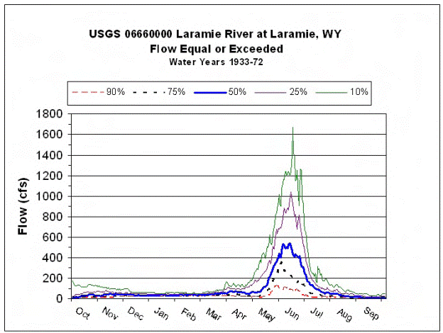
2. We have talked about the variability of river
discharge. There are many ways of
looking at how river discharge varies. A
useful type of plot is shown below, which nicely shows that the Laramie river typically has only one flood (snow melt dominated) in
early summer.
For this exercise, we
are going to look at something that is of major interest to many, the question
of the likelihood of large floods. Here
is some data from the Laramie river at Laramie:
Flow measurements as
reported on UPRR quarterly Discharge Monitoring Reports (DMR) for WDEQ Permit
WY0032590,
Laramie Tie Plant.
Year
Oct
Nov Dec
Jan Feb
March Apr May June July
Aug Sept
Streamflow
(cfs)
1987 8.1 77
49 54 65
62 157 46 22 7.8
4.5
1988 28 40
26 7.9 7.0 68 201
508 680
48 8.9
5.5
1989 17 44
34 7.1 2.0 61 nr
16 45 13 11 13
1990 36 75 60 27
30 189 36 30 351
50 20
10
1991 7.9 41
76 11 24 104 20
169 612 19 21 11
1992 231
1993 49 102
147 196
264 309
39 407
1016 115 11 36
1994 14 38
67 177 209 93 53
288 77 7.6 7.0 4.7
1995 45 55
53 86 65 68 6.8
111 1281 281 14 15
1996 51
62 88 77 68 79 107
552 1136
420 20
21
1997 115 128
115 55
62 82 101 503 1277
149 110
87
1998 34
55 63 70 75 87 100
305 425
139 66 29
1999 20 18
67 56 60 75 68 496 1126 267 20
17
2000 18 40
13 84 72 45 54
297 101 18 6 13
2001 56
20 54 77 90 75 21
177 66 11 18 26
2002 11 16
21 160 207 174 32
68 56
2003 18
49 68 28 22 22 20
230 556 14
2004 131 122
113
68 83 72
2005 47 49
81 94 98 90 53
306 1115 95 80 16
2006 188 201
200 126
109 107
159 386
105 187
109 115
2007 143 104
68 200
186 281
146 549
378 78
109 34
2008
68
68 68 98 469 1715
316 180
169
The
above table shows typical problems with flood analysis. Real data sets have missing and questionable
data. The above table lists measurements
taken once a month, obviously it probably misses the actual flood peaks. There are more subtle problems with stream
data: even if you find more continuous data (e.g. USGS typically reports daily
discharge), the actual discharge is not measured, but estimated from river
depth. Any bed or bank erosion or
deposition will create errors in this depth based estimate, this is especially
a problem at high flows when erosion/deposition is common. The biggest problem with the Laramie river data, is that over time, various water projects have
diverted water from the river. As a
result, the flood data is not ‘stationary’, in other words the flood data does
not represent a sample from the same river over time. The river has been changing, so that we can’t
trust the old data to predict the future.
Question 2.
Use
Google Earth to find the width of the Laramie river near Optimist Park,
specifically near the bridge on W Garfield st..
a)
The largest flood in the above record was in 2008, at 1715cfs. How deep would this flow have been under the
Garfield bridge,
IF the river stayed in its banks.
Use Manning’s equation, and the slope from previous question. [hint remember
discharge is w*v*d, and you will have to convert from cfs
to m^3/s]
b) Hard, if you had to use the data in the table for a
specific purpose, such as calculating yearly discharge: 1- how would you use
the data for April 1995? 2- And how would you deal with the data for 2002 thru
2004. 3- Is there anything you can do with the 1992 data?
Question 3, recurrence
intervals or ‘100 year floods’
Grey
River, at Dobson New Zealand
1968
to 2004
|
year |
Max flow (m3/s) |
|
|
|
1997 |
5950.8 |
|
|
|
1988 |
5840.4 |
|
|
|
1998 |
5670.0 |
|
|
|
1970 |
4899.1 |
|
|
|
1994 |
4844.5 |
|
|
|
1977 |
4841.4 |
|
|
|
1984 |
4814.3 |
|
|
|
1983 |
4228.2 |
|
|
|
1969 |
4203.4 |
|
|
|
1972 |
4125.6 |
|
|
|
1975 |
4117.8 |
|
|
|
1980 |
4039.4 |
|
|
|
1973 |
4012.5 |
|
|
|
1979 |
4000.9 |
|
|
|
1982 |
3975.2 |
|
|
|
1996 |
3866.7 |
|
|
|
2000 |
3809.5 |
|
|
|
1974 |
3771.7 |
|
|
|
1968 |
3678.3 |
|
|
|
2002 |
3517.9 |
|
|
|
1976 |
3463.4 |
|
|
|
1981 |
3448.9 |
|
|
|
1993 |
3422.3 |
|
|
|
2001 |
3342.7 |
|
|
|
1978 |
3302.9 |
|
|
|
2004 |
3224.6 |
|
|
|
2003 |
3221.9 |
|
|
|
1989 |
3217.1 |
|
|
|
1995 |
3185.8 |
|
|
|
1992 |
3177.6 |
|
|
|
1991 |
3091.4 |
|
|
|
1999 |
3070.0 |
|
|
|
1990 |
2806.8 |
|
|
|
1971 |
2420.5 |
|
|
|
1987 |
2385.4 |
|
|
|
1986 |
2364.9 |
|
|
|
1985 |
1794.8 |
|
|
|
|
Mean 3761.0 |
|
|
|
|
|
|
|
Question 3
To continue thinking about river floods, we will look at some better quality data from the Grey river.
a. Calculate the recurrence intervals for floods on the Grey River. Recurrence intervals are what are usually somewhat misleadingly quoted in the popular media as the 100 year flood or whatever the news person wants to emphasize. There are a variety of methods to calculate recurrence interval, but probably the simplest is as follows: order your data from largest to smallest (this I have done for you). Now apply the following formula to each datum:
Tr = (N+1)/n, where N is the total number of observations, n is the ranking in the above list from top to bottom (eq the second from the top is n=2) and Tr is the recurrence interval in years.
b. Plot the recurrence intervals on a semi log plot. Use log time on the x-axis and discharge on the y-axis. We will use a log axis, however there is considerable discussion in the literature about the expected shape of a recurrence interval curve, or more precisely, how floods should be distributed in time. (If you would like to investigate this more, look up Gumbel Distribution on the web.) We use a log plot since it is straightforward to plot, not because it is correct.
c. Use your plot to estimate the 100year flood on the Grey river. Comment on the accuracy of your prediction.
d. The channel forming discharge for a meandering river is typically about the 2year flood. What is the 2 year flood on the Grey River.
4 (this
weeks geomorphic puzzle) In class I quickly sketched
the energy argument for the difference in behavior of super-critical and
sub-critical flow. The development in
class was a sketch of the tradeoff between potential energy and kinetic
energy. I want you to understand this
important concept: that water only has so much energy, and the trade off from
kinetic to potential (or vice versa) controls a lot of the rivers
behavior. I would like you to follow the
logic outlined here and find solutions to illustrate this behavior.
Consider
a rectangular channel of constant width and steady discharge, which has a small
bump of height ‘h’ which the flow
must cross. Assume the slope of the flow
is so low that we can ignore it and set the elevation of the bed of the
incoming flow to be 0, while the bed of the flow over the bump is just h. We will call the initial location 1 and the location at the bump 2.
The
incoming depth is d1 and
the incoming velocity is v1,
since the width is constant, we just look at a 1m wide section of this
flow. The flow over the bump will have
depth d2 and velocity v2, and the water surface
height over the bump is d2 +
h. Although we don’t yet know values
for d2 or v2: they will tell us if the
water surface goes up or down, and that is what we solve will for.
The mass flux of water per time incoming is r*v1*d1 and the mass over the bump is the same
(or equivalently r*v2*d2).
The
kinetic energy of the water is the mass times the square of the velocity
divided by 2, while the potential energy is the mass times gravity times the
height (d1/2). To get the total energy in a column we must
multiply by the depth. Since the flow
velocity is changing, it is important to multiply by the local velocity (v), to get a total energy flux per unit
width per time at each of the two locations.
We assume no energy is lost between points 1 and 2, and so we can write the
energy balance for K.E. and P.E. as a statement that the energy flux per time
at the two places is equal: [equation A]:
r*v13*d1/2
+ r*g*v1*d1
*d1/2 = r*v23*d2/2
+ r*g*v2*d2
*(d2/2 + h) ,
where we have been careful to include the
extra height of the bump (h) in the
potential energy at location 2. This simplifies considerably since r*v1*d1 is equal to r*v2*d2
. Further simplification occurs if we write v2 = v1*d1/d2 and multiply the whole equation by d22, to get [equation B]:
0 = [g*v1*d1] *d23 + [2*g*d1*v1*h
- v13*d1 - g*v1*d12] *d22 + [v13*d13
],
where all terms in ‘[ ]’
brackets are known if we know v1*d1 .
This is a cubic equation in d2 . (e.g. the equation is simply 0 = a*d3 + b*d2
+ 0*d + c)
a. Write equation A and write
what each term represents, and produce equation B by the indicated steps.
b. To see what the Laramie river
might do in encountering a bump in the bed, try putting an input velocity of
1m/s, a depth of 1m, and a bump height of 0.1m.
How much does the water surface drop over the bump? (don’t forget to add
the height of the bump to get the water surface. You can directly solve the cubic, or use a
web app. [you are looking for the real
root] Or it is a fairly quick iteration to get a
solution: try a d2 of 0.6m to start, improve on that if you can)
c. If you have made it this far; Finally, just to see the opposite behavior
for high Fr number flow,
try this with a (unrealistic) flow velocity of 5m/s, depth of .5m and bump of
0.1m.